Unit One: Ancient World-Civilizations and Religions (4000 B.C.E. to 500 C.E.)
Technological and Environmental Transformations
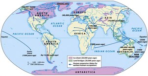
To better understand history, a good place to start is with the Understanding our Past handout and with the Ancient Afterlife handout. The question of when does history start is answered by when we record and art is critical to this theory. Excellent evidence can be seen with the Ancient cave paintings presentation. The transition from the Neolithic Era to a more advanced society is indicated in this Prehistory to civilization chart and the Spread of Humans map links. Finally there is a special document called What makes a Civilization handout.
River Valley Civilizations
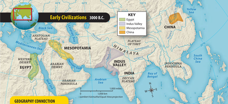
The river valley civilizations are in a specific order and the first is a lesson on Mesopotamia which lies between the Tigris and Euphrates rivers and forms a crescent shaped area of rich agricultural wealth. Language is a key part to a civilization and this link opens to the Progression of Cuneiform chart. Writing will develop and special focus on examinations often uses this Epic of Gilgamesh textbook extract.
The next river valley civilization begins with the Ancient Egypt lesson. A good overview is the Life in Ancient Egypt article and handout. To gain a better understanding of the geography of Egypt this satellite view of the Nile River shows the vast scale of the region. The final example of this advanced society is the Egyptian Calendar.
The "lost" Indus River Valley civilization has been studied by archaeologists and historians since it was located and the information in this document shows their complex ways of life. In addition, please open the document Indus River reading and answer the key questions that are at the end of the handout.
It is critical to fully understand this next section as it leads to several sections throughout the year. The first document is a Lesson on Ancient China and then this is accompanied by an Ancient China presentation. Artifacts are key to understanding any society and this presentation shows an Ivory Carving from Ancient China, excellent evidence of their art and culture.
Early Mesoamerica
Included in this unit are non river valley civilizations and the first covered uses the Mesoamerican Empires lesson which is accompanied by a Mesoamerican City-States map. In Peru and other areas of the Andes Mountains, the Incas ruled and this is a map and photos of the Inca Road systems which were important to linking their empire.
Afro-Eurasian Movements
Africa is such a vast continent and the progression of societies is an important part of this unit. How people spread into this region is shown in the Indo-European Migrations map. One ethnic group in particular is often asked on examinations and they can be best identified with the Bantu Migrations lesson.
Organization and Reorganization of Human Societies
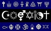
All societies develop their own religion as time progresses and this section covers some of the basic religions or belief systems and their origins in the world. A good place to start this section is by reading the What is Religion? a short handout that answers many questions. In addition, I have created a summary of the major Religions and Belief Systems.
Individual Religions and Belief Systems
The first is a chart of the Key facts and beliefs of Judaism. This is a simple document that covers only the basic components of the religion.
Another of the oldest religions is Hinduism and The Gupta Empire establishes a society based on the caste system. Two unique ways of understanding Hinduism is to look at the Hindu goddess Raina photograph and then the map showing the Spread of Hinduism.
Stemming from Hinduism is another religion and this document is a lesson on Buddhism. To gain a better insight I have included an academic article on Buddhism which explains more details on the subject. The spread of both Hinduism and Buddhism map shows how these two religions spread into Southeast Asia and changed their cultures. The spread of Buddhism and Cultural Diffusion is seen in Japan where it was adapted to create Shintoism and the attached handout explains some of the rituals and procedures involved with this belief system. The section on Buddhism is concluded by examining the Mauryan Empire and the rule of Ashoka who ruled his society in a unique way.
In the end of January or early February, depending on the calendar, I like to use the following Chinese New Year lesson as it really gives a unique insight as to the traditions and cultures of Ancient China , many of which are still followed today. Two lesser known religions or belief systems are covered by this lesson on Animism and Shamanism.
Finally, the last of the major religions is covered by this handout on Muslim History. As a supplement, I have created a quick reference sheet on Islam which summarizes the key concepts of this religion. Muslim society created superb architecture and their work has ben captures in this presentation on Islamic Mosques. The present turmoil within the Muslim world is partly because of the Difference between a Sunni and Shiite Muslim and this handout covers some of the major differences. Finally, I have added another scholarly document that discusses the Islamic Economy and Society.
States and Empires
This section of the unit is best identified with a study of two societies, the Muslims and the Chinese. For each there are four important documents that show Pre-Islamic Arabia map which will lead to the rise and fall of the Persian Empires. The spread of religion and cultural diffusion is associated with wars and trade. Trade is the key component to understanding the map of the Spread of Islam and then the presentation on the Muslim Trade Routes.
China saw itself as the Middle Kingdom, the center of the world. Often isolated throughout history, it was ruled by many different clans or families and the attached is a table of the Dynasties of China. How this system worked is shown by the Dynasty Cycle illustration. There were times when China exerted its powers and the Chinese influence over Korea and Japan document which is accompanied by this Chinese influence over its neighbors map relate to these important times within their history.
Land and Water Routes for Interregional Trade
Trade is such an important part of ancient history and to better understand how societies grew and used advanced technology is seen with this presentation on Early Sailing ships. Trade across Eurasia goes back thousands of years and one area of special focus is the lesson on The Silk Road which is accompanied by a Map of the Silk Road from Easter Europe to China.
The City-States of Ancient Greece and Rome
Before the days of Greece and Rome, one society emerged that relied on trade and was an integral part of the formation of the two Mediterranean societies. They were the early people of the Aegean Sea.
An excellent way to start this section of the unit is with the presentation on Ancient Greece. Many students covered the difference between Athens and Sparta in middle school but there were Four forms of government in Ancient Greece. To simplify learning, I have added a Timeline for Ancient Greece, an Ancient Greece and its colonies map and then a chart of Great Greeks. Two societies dominated Ancient Greece and this is a comparison chart for Athens versus Sparta plus a map of the City-States of Ancient Greece to give a batter understanding of how the geography and terrain of the region isolated many regions into city-states. Where was the great empire of Carthage? This handout explains the answer plus I have added a map of the Peloponnesian War.
Hellenic culture was created during the empire of Alexander the Great and this link shows his vast empire with the aid of a map. Perhaps Alexanders greatest goal and achievement can be seen by examining the handout Alexandria during the time of Alexander the Great.
The rise and fall of the Roman Empire is covered in this next section. It begins with the Ancient Rome lesson and includes a picture of the statue of Romulus and Remus. To show the size of the Roman Empire at its height, I have added the Roman Empire in 100 C.E. map.
The Romans were known to have traded with many regions, even as far as the Han Empire in China via the Silk Roads. This map shows a version of the Early Roman World, Orbis Terrarvm. It is important to note that certain parts of the world are not shown on this map.
The first Romans were polytheistic but this changed over time and was a major cause of the fall of Rome. The following is a lesson and short summary on Christianity which caused many problems within the empire. The Decline of the Roman Empire handout adds the other problems that caused this mighty empire to collapse.
A very common essay question is a comparison of the Roman and Han Empires as both of these empires once traded along the Silk Road. They emerged around the same time period, achieved great wealth in their prime and suffered similar problems causing their declines.
Finally, in Eastern Europe and then spreading into Eastern Africa was a different version of Christianity. This document explains what is Coptic Christianity? and it is important to understand now as it will reoccur later on in the school year.


